Most repeated positive
13authors
A complete feature set
“cleanshotx - scrolling screenshots is much more robust.”Evidence: r/macapps · Shottr vs CleanShot X in 2026. Which one are you actually sticking with?

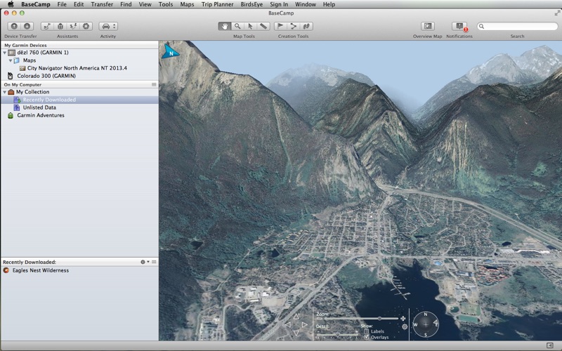
Garmin® BaseCamp® provides an interface for viewing Garmin map products and managing geographic data. With BaseCamp, you can perform the following tasks: • Transfer data to and from your Garmin device. • Plan multi-day trips using Yelp® an…
Release notes parsed from trusted records and kept on this page. History provides context; a future Watch alert starts from a fresh baseline.
Fixed compatibility issues with macOS 11 Big Sur
Be the first to request it
Request the same source-linked purchase brief shown in the completed example below. Your email starts the request and receives the result.
Want it sooner? Independent demand changes queue priority.
Completed example · CleanShot X data
Everything below belongs to CleanShot X. It is a real, completed example—not research about Garmin BaseCamp.
CleanShot X
Example data
 Completed research example
Most repeated positive
13authors
“cleanshotx - scrolling screenshots is much more robust.”Evidence: r/macapps · Shottr vs CleanShot X in 2026. Which one are you actually sticking with?
Most repeated concern
16authors
“I don't think it makes sense to spend the money for Cleanshot when other apps do most of what it does for a lot less or free.”Evidence: r/macapps · Shottr vs CleanShot X in 2026. Which one are you actually sticking with?
Product context
Official or maker-supplied product information. It is kept separate from buyer evidence and independent purchase verification.
Garmin® BaseCamp® provides an interface for viewing Garmin map products and managing geographic data. With BaseCamp, you can perform the following tasks:
• Transfer data to and from your Garmin device. • Plan multi-day trips using Yelp® and your map data • Create, view, edit, and organize waypoints, routes, and tracks. • Find places, such as addresses, points of interest, and public land survey areas included in your detailed map data. • View map data in 2D and 3D. • View topographical information included in your detailed map data. • Geotag photos with geographical location information. • Print detailed topographical maps, PLS quads, and multi-page poster maps. • Download and view BirdsEye™ satellite imagery and topographic raster maps. • Import and view Garmin Custom Maps. • Create, share and download Garmin Adventures (http://adventures.garmin.com)
Fixed compatibility issues with macOS 11 Big Sur
More Travel apps from the directory.


