Most repeated positive
13authors
A complete feature set
“cleanshotx - scrolling screenshots is much more robust.”Evidence: r/macapps · Shottr vs CleanShot X in 2026. Which one are you actually sticking with?

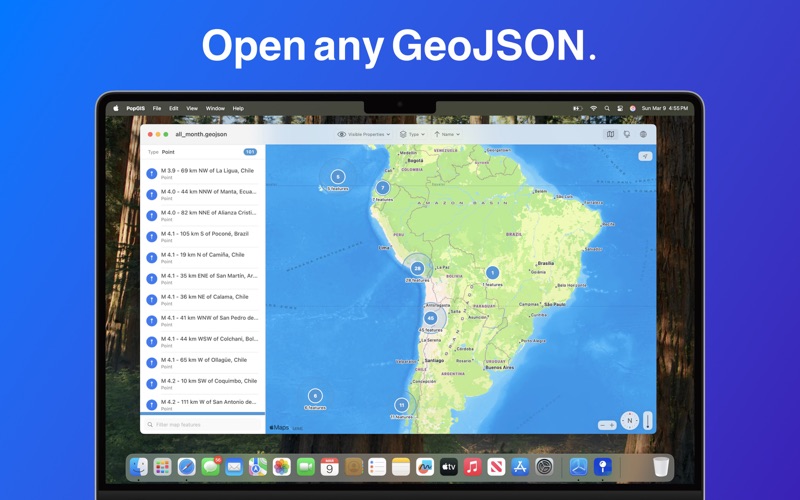
PopGIS is the simplest tool to view and edit GeoJSON files on your Mac. Open and edit geospatial datasets on your Mac using RFC 7946 compliant .json and .geojson files - import data from web feeds, APIs, and public data sources. * Search a…
Release notes parsed from trusted records and kept on this page. History provides context; a future Watch alert starts from a fresh baseline.
This release fixes a bug that prevented edits to feature properties from saving correctly.
Be the first to request it
Request the same source-linked purchase brief shown in the completed example below. Your email starts the request and receives the result.
Want it sooner? Independent demand changes queue priority.
Completed example · CleanShot X data
Everything below belongs to CleanShot X. It is a real, completed example—not research about PopGIS - GeoJSON Maps + GIS.

CleanShot X
Example data
 Completed research example
Most repeated positive
13authors
“cleanshotx - scrolling screenshots is much more robust.”Evidence: r/macapps · Shottr vs CleanShot X in 2026. Which one are you actually sticking with?
Most repeated concern
16authors
“I don't think it makes sense to spend the money for Cleanshot when other apps do most of what it does for a lot less or free.”Evidence: r/macapps · Shottr vs CleanShot X in 2026. Which one are you actually sticking with?
Product context
Official or maker-supplied product information. It is kept separate from buyer evidence and independent purchase verification.
PopGIS is the simplest tool to view and edit GeoJSON files on your Mac. Open and edit geospatial datasets on your Mac using RFC 7946 compliant .json and .geojson files - import data from web feeds, APIs, and public data sources.
* Search and filter geospatial features based on properties * Open large files up to 250MB+ in size * Pan, tilt, and zoom the map with intuitive controls * Edit individual properties to correct errors and mistakes * View the latest satellite and vector base layers from Apple Maps * Preserve your privacy: no tracking, no ads, no data collection
Terms of Service: https://www.apple.com/legal/macapps/stdeula/ Privacy Policy: https://popgis.com/privacy/
This release fixes a bug that prevented edits to feature properties from saving correctly.
More Navigation apps from the directory.
