Most repeated positive
13authors
A complete feature set
“cleanshotx - scrolling screenshots is much more robust.”Evidence: r/macapps · Shottr vs CleanShot X in 2026. Which one are you actually sticking with?

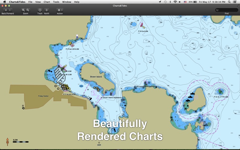
Charts&Tides is the new must-have marine navigation software for the Mac. It provides access to charts, tides, ActiveCaptain information, GPS navigation and more in a well designed and integrated package. Use it at home to research and pla…
Release notes parsed from trusted records and kept on this page. History provides context; a future Watch alert starts from a fresh baseline.
Be the first to request it
Request the same source-linked purchase brief shown in the completed example below. Your email starts the request and receives the result.
Want it sooner? Independent demand changes queue priority.
Completed example · CleanShot X data
Everything below belongs to CleanShot X. It is a real, completed example—not research about Charts & Tides.
CleanShot X
Example data
 Completed research example
Most repeated positive
13authors
“cleanshotx - scrolling screenshots is much more robust.”Evidence: r/macapps · Shottr vs CleanShot X in 2026. Which one are you actually sticking with?
Most repeated concern
16authors
“I don't think it makes sense to spend the money for Cleanshot when other apps do most of what it does for a lot less or free.”Evidence: r/macapps · Shottr vs CleanShot X in 2026. Which one are you actually sticking with?
Product context
Official or maker-supplied product information. It is kept separate from buyer evidence and independent purchase verification.
Charts&Tides is the new must-have marine navigation software for the Mac. It provides access to charts, tides, ActiveCaptain information, GPS navigation and more in a well designed and integrated package. Use it at home to research and plan your trip or add a GPS device and use it on your boat to navigate a route to your final destination.
Charts&Tides was designed with ease of use in mind. The interface is intuitive and tasks have been streamlined. Unlike other marine software, you no longer need to download, store and manage individual charts or load them into the software; we have done the legwork for you and compiled large area charts that combine information from multiple sources.
In more detail: - Provides continuous and seamless large area charts derived from NOAA and CHS vector cartography. - Shows tide levels and current speeds on the chart using easily interpreted icons. Allows you to judge the water situation around you with a single glance. - Integrates with the ActiveCaptain interactive cruising guidebook providing you with access to thousands of marinas, anchorages, hazards and other local knowledge. - Stores the entire ActiveCaptain database offline so that it is always available to you, even without an Internet connection. - Allows you to instantly search thousands of chart features and the ActiveCaptain database. - Supports waypoints, routes, tracks and allows you to import and export them in GPX format. - Supports GPS devices that transmit in the NMEA 0183 or GPSD format. Route navigation with automatic waypoint sequencing is supported. - Supports AIS devices and Closest Point of Approach (CPA) computations and alerts, including spoken alerts. Set the CPA and TCPA and hear the computer speak the alerts to you! - Comes with a dark UI that looks good during the day and will preserve your night vision when it is dark.
The software comes with a world base map, but does not come prepackaged with any detailed marine charts. You can purchase detailed marine charts from within the application. You can also use the software without purchasing additional charts.
- Updated for OS X Yosemite - Misc other fixes
More Travel apps from the directory.


